April 24, 2026, 11:31 pm

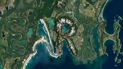

Did you know that NASA’s tool helps you discover your name hidden in Earth’s landscapes? NASA has released a fascinating online tool that allows people to find their names written in natural landforms, such as coastlines, hills and rivers. This is done by applying data from the Landsat mission (over 50 years of data) and using high-quality pictures taken from space to identify landforms shaped like letters of the alphabet. Therefore, the research results are converted into an engaging experience and interactive online tool for the public that shows names written in many different areas of the Earth’s surface. This combination of advanced science (remote sensing) with interactive public display demonstrates how advanced satellite systems can be used to identify artistic patterns in the Earth’s surface.
NASA developed an interactive website called ‘Your Name in Landsat,’ where individuals can enter their name, and the system will identify imagery from NASA’s Landsat program, which contains images of each letter using the natural formations of Earth. NASA and USGS have developed an extensive collection of high-quality, multi-spectral (several different wavelengths) images taken since they began working together in 1972.
The letters are generated with satellite images that have been collected over the past several decades. Since 1972, with a joint partnership between NASA and the USGS, Landsat has been continuously providing earth images and uses sophisticated instruments to capture light reflected off the Earth’s surface, allowing scientists to track changes in land use (such as loss of glaciers or the growth of cities).
As noted by NASA, the Landsat program is regarded as the ‘gold standard’ for observing the land surface of the Earth. These data are critical to managing the earth’s resources, monitoring the health of forests, and determining the effects of climate change. The technology that creates your name has been used by scientists to examine how ecosystems on our planet have changed over time.
The ‘Your Name in Landsat’ project provides a simple, interactive way to engage with decades of Earth observation data. Follow these steps to generate your own satellite art: